THE persistent heavy rain in the country has led to widespread havocs, with more than 30 houses and a school demolished, cornfields destroyed, and livestock missing in Mbeya.
According to eyewitnesses the incidents in Itezi Ward, Uyole valley unfolded yesterday morning amidst the continuous downpour, where a massive landslide from Kawetele mountain resulted in extensive damage, including completely destroying Generation Primary School building, except for one classroom and an office being spared.
"Thanks to the swift intervention of local residents, and the prompt response of regional and district committees following the disaster, I have also reached out to Speaker Dr Tulia Ackson, who is our Member of Parliament, who was on her way here to assess the situation firsthand," Councillor of Itezi Ward on Gombe Kaskazini Sambwee Shitambala said on Sunday.
"The aftermath of the landslide has left many individuals displaced, losing their homes and livelihoods, while the fate of those affected remains uncertain, we pray to God that it doesn't reoccur," he pointed out.
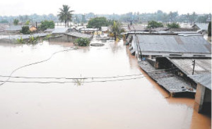
Meanwhile, the government has emphasised that the Julius Nyerere Hydropower Project (JNHPP) was not responsible for the recent floods in Rufiji and Kibiti, while highlighting that without the dam's intervention, the floods could have been more severe.
The Chief Government Spokesperson, Mr Mobhare Matinyi, shared these insights during a press briefing in Dar es Salaam, addressing journalists from various media outlets to provide updates on the rain and flood situation in the country, which has tragically resulted in 58 reported deaths nationwide due to ongoing heavy rainfall.
"The JNHPP was constructed not only to generate electricity but also to manage flooding risks. So, without the dam's intervention possibly the flood could have occurred as early as October last year," Mr Matinyi, who is also the Director of Information Services, MAELEZO, said.
He added that, "The dam's current water capacity stands at 32.782 billion cubic metres, allowing for better control and management of water levels, thereby aiding in flood prevention and protection of lives and property. Furthermore, Matinyi highlighted the technical stability of the JNHPP, noting that the recent water intake from the Rufiji River had decreased to 6,100 cubic metres per second; significantly lower than the peak recorded in February this year, which stood at 8,445 cubic metres per second. "The condition of the JNHPP is technically good because, until Saturday, the amount of water that was entering the dam from the Rufiji River had decreased and reached 6,100 cubic meters per second, compared to the highest amount of 8,445 cubic metres per second," he expressed.
The dam's dimensions, spanning 100 kilometres in length and 25 kilometres at its widest point, underscore its significance in water storage and flood management.
According to him, the Rufiji River basin area has a long history of flooding; in May 1974, the record for the amount of water that flowed through the river to the ocean was 13,212 cubic metres per second.
According to Mr Matinyi, in order to fight the flood in the area, the government intends to construct two more dams.
"Let me inform you that the government will construct the Ngorongo dam, which will cater for the villages of Ngorongo, Mkongo, Ruwe, Nyamwage, and Ikwiriri South. It will have the capacity to take 164 million cubic metres, and the expectation is to help with irrigation," he said.
"The other one is the Mbakia Mtuli dam, which will involve the villages of Umwe, Chumbi A, B, and C, Mbakia Mtuli, and Muhoro and will have the capacity to take 1.1 million cubic metres," he added.
Regarding the floodaffected regions, Mr Matinyi detailed the extensive impact on various areas, particularly in the Coast and Morogoro regions, with a total of 58 reported fatalities national wide.
He said that it was reported that the updates showed that ten people died in Arusha, two in Dar es Salaam, four in Geita, five in Iringa, one in Kilimanjaro, four in Lindi, six in Mbeya, five in Morogoro, ten in Rukwa and 11 in Coast Region.
"The biggest effects of the floods are in the Coast Region (Rufiji and Kibiti districts), involving a total of 17 wards, where 12 are from Rufiji and five are from Kibiti and in Morogoro Region, the affected areas are Malinyi District Council with a total of 50 wards: Ulanga eight wards; Mlimba three wards; Ifakara nine wards; and Morogoro Municipality 22 wards," he said.
Sign up for free AllAfrica Newsletters
Get the latest in African news delivered straight to your inbox
Explaining the immediate government responses include search-and-rescue operations, with over 2,278 individuals rescued thus far.
Temporary camps have been set up to accommodate disaster victims, totalling 1,529 individuals across eight locations. He said, humanitarian aid efforts are also underway, with provisions such as 40 tonnes of corn, 500 mosquito nets, 400 blankets, and 5 tents allocated to support affected communities.
Additionally, deliveries of essential supplies including 43 tonnes of flour and 25 tonnes of beans are on route to Rufiji to further assist those impacted by the floods.
The government remains committed to addressing the aftermath of the floods, extending assistance and support to affected citizens while prioritising their safety and wellbeing during this challenging period.